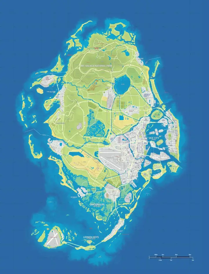
Positions are estimates from gtadb.org's community reconstruction. Its research includes official and unofficial material; a marker is not confirmation by Rockstar Games.
How the 82.6 km² land estimate was measured
LeonidaBay measured about 82.6 km² of land by counting pixels on the YANIS V17 community map, using a scale of one metre per pixel. This is the reconstruction used on GTA6Maps.wiki. Rockstar has not confirmed that area for the finished in-game map.
GTA 6 vs GTA 5, GTA 4 and RDR2
LeonidaBay traces different boundaries for each game. The study’s comparison depends on what its outlines include.
| Game | Boundary used by LeonidaBay |
|---|---|
| GTA 6 | Land in the YANIS V17 community reconstruction of Leonida. |
| GTA 5 | Land of Los Santos and the surrounding GTA V map under the study's boundary. |
| GTA 4 | Land on the Liberty City map in this comparison, excluding water between the islands. |
| Red Dead Redemption 2 | Playable world, including lakes and rivers within the trace. |
Rockstar gave The New York Times a different kind of comparison: GTA VI's map is about three times the playable area of Red Dead Redemption 2. The interview does not supply a measured square-kilometre figure or a shared polygon boundary. Multiplying a fan land estimate for RDR2 by three would mix Rockstar's playable-area language with the fan trace's land definition.
How the area breaks down by region
You can inspect all six settings above, but the point data does not give us closed region boundaries. A defensible regional breakdown would need a consistent coastline and a rule for where the city, wetlands and inland areas meet. Until that exists, these are the area decisions that affect a breakdown:
| Region | Boundary or measurement decision |
|---|---|
| Vice City | Decide whether to include Vice Beach and detached islands in the metro area, and report any bay water separately. |
| Leonida Keys | Trace the land of each island around Key Lento. A broad outline around the chain would include large areas of sea. |
| Grassrivers | Specify how flooded terrain, canals and open water count. The Visitor Center is a reference point for terrain, not a boundary. |
| Port Gellhorn | Distinguish the built-up town from its wider surroundings and coastline. |
| Ambrosia | Use a defined area boundary around the industrial and agricultural land. The refinery pin is only a point. |
| Mount Kalaga National Park | Trace the edge of accessible terrain around the peak separately from scenery outside the playable boundary. |
Check the definition before comparing two numbers
Look for a map version, a scale and a note about what was included. A land-only figure should exclude open water. A playable-area figure needs rules for offshore travel and for terrain behind an invisible boundary. A rectangular image frame includes empty space around the map and can be far larger than either of those figures. Keep those measurements separate when you compare the games.
Use the GTA 6 Full Map to zoom out and see the shape of the state or the State of Leonida Map for a named anchor in each major setting. Neither the number of pins in an area nor the time it takes to drive through it gives an area in square kilometres.
Frequently asked questions
How big is the GTA 6 map in square kilometres?
82.6 km² of land is LeonidaBay’s estimate for the YANIS V17 community map. A measurement of the final in-game map remains unverified.
Is GTA 6 three times the size of RDR2?
3 times RDR2’s playable area is the comparison Rockstar gave The New York Times for GTA VI. The interview gives a ratio and leaves the area in square kilometres unspecified.
How big is Vice City on its own?
2 measurement choices affect any city-only figure: the city boundary and how water is counted. A measured official area for Vice City remains unverified.
Can I calculate land area from the printable map?
2 things are needed to measure land from the printable map: a reliable scale and a traceable land boundary. A stylised poster may provide neither.