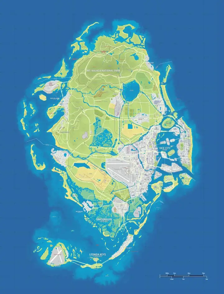
Positions are estimates from gtadb.org's community reconstruction. Its research includes official and unofficial material; a marker is not confirmation by Rockstar Games.
The state and its six main settings
Leonida is the fictional state in GTA 6. Vice City is one part of it. Use the regional sections below to tell a city from a wider setting. A town, national park and chain of islands are all useful ways to divide a map, even though they describe very different kinds of places.
Vice City
Rockstar's city tour moves between Ocean Beach, Little Cuba, the Tisha-Wocka flea market and VC Port. Use the city marker for orientation and the individual district markers when you need to distinguish the beachfront from the mainland. Miami is the broad analogue. The location of a street in real Miami cannot tell you where the corresponding fictional street begins.
Real-world analogue: Miami and Miami Beach. Map anchor: Vice City.
Leonida Keys
The Keys are the island setting associated with Jason and his friend Cal. The chain has a different shape from an inland town: water can separate two places that look close at low zoom. Key Lento is a community-mapped reference point in the island chain. Its marker opens a useful area view without implying that every island name or bridge connection on the fan map has been verified.
Real-world analogue: Florida Keys. Map anchor: Key Lento.
Grassrivers
Rockstar shows a wetland landscape with airboats, substantial wildlife and low visibility in places. The community dataset places its Visitor Center marker in Mariana County. Use the marker as a way into the wetland area. The county label is a field in the site dataset and does not establish an official boundary for Grassrivers.
Real-world analogue: Florida Everglades. Map anchor: Grassrivers Visitor Center.

Port Gellhorn
Rockstar describes a town whose tourist trade has declined. On the site map, the welcome sign, train station and raceway give you specific markers to compare with the town-level pin. A real Gulf Coast town can help explain the setting, but the available material does not establish a single exact real-world counterpart or make any of its road names transferable.
Real-world analogue: Gulf Coast resort towns, as a broad analogue. Map anchor: Port Gellhorn.
Ambrosia
Rockstar names the Allied Crystal refinery in its Ambrosia profile. The site has both a town-level marker and an Allied Crystal area marker, which are useful at different zoom levels. In the data, the latter is an estimated area centre. It should not be used as a gate, an entrance or evidence that a building interior is accessible.
Real-world analogue: South Florida's sugar-producing interior, as a broad analogue. Map anchor: Ambrosia.
Mount Kalaga National Park
Mount Kalaga is a landmark inside the park area. The community dataset points to Table Rock Mountain in North Carolina as a visual reference for the peak. That association is useful for recognizing the landscape. The peak marker cannot tell you where the park ends or whether every surrounding track is a usable route.
Real-world analogue: Appalachian-style terrain, as a visual analogue. Map anchor: Mount Kalaga.
Region comparison
| Area | What to look for | Useful first map reference |
|---|---|---|
| Vice City | The dense coastal metropolis, including the beach, port and Little Cuba. | Vice City |
| Leonida Keys | A chain of low-lying islands, bridges and waterside communities. | Key Lento |
| Grassrivers | Wetlands, shallow waterways and airboat country. | Grassrivers Visitor Center |
| Port Gellhorn | A former tourist destination with roadside motels and entertainment venues. | Port Gellhorn |
| Ambrosia | An inland industrial area identified by the Allied Crystal sugar refinery. | Ambrosia |
| Mount Kalaga National Park | Rockstar's northern wilderness with forested hills and outdoor recreation. | Mount Kalaga |
How towns, districts and counties fit together
Rockstar's six featured settings are a practical way to learn the state. The Regions & Cities map also lists community-marked towns, islands and counties. A label such as Vice-Dale County is a county-level entry in that index. Ocean Beach is a district-level entry. When you already know which district you need, go to the district or landmark pin instead of starting at the state label.
The same distinction helps when you browse photos. An official image labelled Leonida Keys identifies the setting of the scene. Matching an island or an exact road junction inside the photo requires additional evidence. In cases where the map only offers a nearby reference point, treat its name and its coordinate as separate pieces of information.
Use this page for the geography and Leonida Map when you want a short list of stops to open from the map. For every available marker type, the GTA 6 Full Map includes a complete index of the site's current categories. Rockstar's Only in Leonida profiles cover the places and characters shown by the publisher.
Frequently asked questions
Is Leonida the same as Vice City?
1 of Rockstar’s 6 featured Leonida settings is Vice City. Leonida is the fictional state that contains the city, the Keys and the other featured settings.
Is Leonida based on Florida?
3 Florida references help explain Leonida: Miami for Vice City, the Florida Keys for Leonida Keys and the Everglades for Grassrivers.
Does Rockstar confirm all of the town and county pins?
6 main settings have official Rockstar profiles. The town and county pins on this map show community-estimated positions.
Can I jump to each region on the map?
6 regional sections each link to a starting marker, using a town or landmark where a region-wide pin is unavailable.