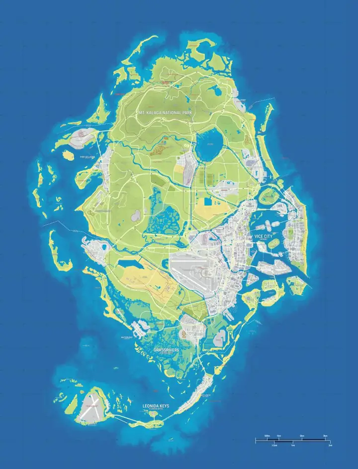
GTA 6 Map Leaked vs Official

Last updated:

Rockstar released its free printable Leonida map on November 19, 2026 through GTA VI Media. The poster labels Little Cuba, Pelican Valley and Breakwater Quarry. GTA6Maps.wiki lists 837 gtadb.org locations in 38 categories. LeonidaBay estimates 82.6 km² on YANIS V17, an area Rockstar has not confirmed.

Mapped locations
837 community records in 38 categories
Featured regions
6 profiled by Rockstar
Estimated land area
82.6 km² from LeonidaBay’s YANIS V17 estimate. Rockstar has not confirmed the area.
Data sources
gtadb.org, Rockstar Games, LeonidaBay
Official printable map
Rockstar GTA VI Media · Download ZIP

Leaked collector’s poster vs. Rockstar’s printable map

We checked GamesRadar’s November 12 report on the retail display photo against the map preview Rockstar published alongside the download. Some features can be matched by name. Comparing fine road details or the complete artwork would require a clearer view of the retail poster.

FeatureReported leakOfficial printable mapWhat the comparison shows
Poster formatThe report describes a photographed map side of a physical collector’s poster.Rockstar’s preview shows a gridded map with a legend. The media page offers the map and cover art as separate printable downloads.The retail photo and the digital map can be compared by their labels. The photo cannot establish whether both editions use identical artwork or print dimensions.
Little CubaGamesRadar reads Little Cuba on the display photo.Little Cuba is labelled west of Downtown in mainland Vice City.The name matches. The official poster gives its position relative to Downtown.
Pelican ValleyThe report identifies Pelican Valley in southern Leonida.Pelican Valley is labelled in Mariana County, southeast of Watson Bay and southwest of Hamlet.The name and its broad southern placement match.
Breakwater QuarryGamesRadar reports the quarry name near an illustration of a UFO.Breakwater Quarry is labelled north of Route 82 and west of Vice City International Airport.The name matches. The reported illustration leaves any in-game UFO encounter unconfirmed.
Highway networkThe photo shows a simplified highway outline.The poster gives route numbers, including I-404 near Port Gellhorn and I-97 through Vice City.The official labels clarify the highway network. The photo provides too little detail to match individual junctions.
Geographic coverageThe report identifies several labels across Leonida.The official sheet spans Mount Kalaga National Park in the north, Vice Beach to the east, and the island chain in the south.The official preview shows the extent of the printed map. The retail photo leaves a complete boundary comparison open.
Free printable editionThe circulating image came from a physical retail display.Rockstar released a free printable map ZIPThe digital download is available directly from Rockstar and can serve as the reference for comparisons with the photo.

Positions are estimates from gtadb.org's community reconstruction. Its research includes official and unofficial material; a marker is not confirmation by Rockstar Games.

Where to download the official Leonida map

Rockstar released the printable map on November 19, 2026. On the official GTA VI media page, open Leonida Map & Cover Art Poster, then choose the printable map. You can also use the direct map download (ZIP).

Which leaked map is being compared?

The comparison uses November reporting on a collector’s poster photographed at a retail display. Earlier development footage has its own provenance. The interactive map on this page uses the gtadb.org community reconstruction.
How to tell a map difference from a game change

For a name, compare the exact text on two readable sources. Check whether one label refers to a county while the other refers to a town or district inside it. If a name is only visible on one map, record that limited observation. A different zoom level, a cropped photo or a reduced legend can account for why a label is missing.

For a road, identify both endpoints and at least one junction. A poster can simplify the route into a single line while the in-game map shows ramps, bridges and local approaches. For an individual point, find a publisher caption or an in-game map label that identifies the place. Then compare its location against an adjoining landmark, since a correct name by itself does not prove the coordinates.

Use the right map for the task

Check Rockstar’s media page for printing, use your in-game map for routes and objectives, and use the community map here to browse the indexed locations. Open Little Cuba to see an example where the publisher confirms the name and the community provides the position. You can also browse the landmark category to see other pins with source notes. The map changelog records when the comparison was checked and what evidence changed.

Frequently asked questions

Where can I get the official GTA 6 map?

19 November 2026 is when Rockstar released the free printable Leonida map. Open Leonida Map & Cover Art Poster on GTA VI Media and choose the printable map option.

Rockstar’s GTA VI media page

Is the leaked collector's map the in-game map?

1 side of a reported printed poster appears in the November photo. Its layout and selected labels leave the full in-game map unverified.

Which map names does Rockstar already confirm?

6 main settings appear in Rockstar’s profiles: Vice City, Leonida Keys, Grassrivers, Port Gellhorn, Ambrosia and Mount Kalaga National Park. Rockstar also names Little Cuba in Vice City.

Does a place missing from one picture mean it was removed?

1 photo cannot establish a removal. Check the same place at comparable scale and coverage in both sources.

Related maps