Last updated:
Official printable map status
Rockstar announced a free digital download of its printable map of Leonida for November 19 in its GTA VI preload announcement. We checked the Rockstar Games media page on November 19, 2026. It listed 138 screenshots, 27 artwork and wallpaper items, 9 clips, and 5 videos. The printable map download was still absent when we checked. Visit the publisher’s media page if you are looking for that edition.
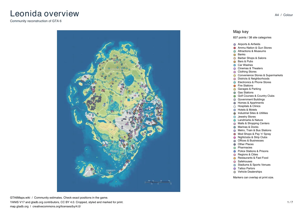
The download on this page is a community-made atlas using YANIS V17. It is a snapshot of the point inventory used on this site. A marker gives you an area to investigate in the game, and crowded parts of Vice City are easier to read by category on the interactive map. Use the atlas to get your bearings or mark a route with a pen while you play.
Download our printable GTA 6 map
Every edition contains the same seven sheets. The first is a statewide view of Leonida. It is followed by Vice City, the Leonida Keys, Grassrivers, Port Gellhorn, Ambrosia, and Mount Kalaga National Park. These are the 6 settings profiled in Only in Leonida. Each regional sheet frames a useful part of the reconstruction around the corresponding setting. Some sheets overlap so that a route near the edge of one page can be followed on another.
Base map and point data are credited to YANIS V17, gtadb.org and its contributors, under CC BY 4.0. We cropped the map for the individual sheets, styled it for paper, and overlaid the site’s markers. The source is the same whether you download A4 or Letter. Regional framing shows a print window, and any map edges on paper reflect that choice of crop.
LeonidaBay estimates the land area at 82.6 km² from YANIS V17. Rockstar has not confirmed that figure. The statewide sheet and the closer regional views use different scales, so a distance on one sheet should not be transferred directly to another.
How to print
- Download the edition for the paper already in your printer. A4 is 210 × 297 mm. US Letter is 8.5 × 11 inches. Both files use landscape pages. Match the paper size in the print dialog so that the key and the footer stay on the sheet.
- Set the scale to 100% or choose Actual size. Disable browser-added headers and footers if you are printing from a PDF tab. Check the print preview before sending all seven sheets. If your printer has unusually wide margins, the preview will show whether the page edge is clipped.
- Choose color for the category colors used in the map key. The monochrome edition lightens the underlying image and uses shapes for broader groups. It is designed for a black-and-white printer and leaves background detail visible beneath the markers.
- To print a subset, type its PDF page number or a range in your print dialog. Start with the overview and the regional sheet you need. When you annotate a location, write its name beside the mark so that you can search for it online at a larger zoom.
What is included
The statewide sheet plots 837 points across 38 categories. The table gives the count for each category in the complete set. It includes settlements and districts along with shops, transport, services and landmarks. On paper, several records can occupy the same small patch. Follow a category link below to pick those points out individually and check their names, sources and locations on the map.
The map key is printed on each sheet, so you can carry the regional page you need by itself. On a longer trip, keep the overview handy to see which sheets share a road or water crossing. Use a category page when a paper symbol is hidden in a cluster of neighboring points.
Frequently asked questions
Where can I find Rockstar’s printable GTA 6 map?
Rockstar announced a free digital Leonida map. At our November 19, 2026 check, the download was not listed on the GTA VI media page. Check Rockstar’s downloads for the publisher’s version.
Which sheets should I print first?
Print the Leonida overview if you want to see how the areas fit together. For a single outing, print the sheet for the area you plan to visit. Each regional sheet has its own title and key, so it also works on its own.
What do the black symbols stand for?
The monochrome edition uses different shapes for shops, services, activities, vehicles and transport, and places and geography. Use the key beside the map to identify the group. The online category map can narrow that down to a specific type of place.
Can I print only Vice City?
Yes. Choose page 2 in the PDF print dialog. The preview above shows it under Vice City. You can print the other regions in the same way by choosing the matching page in the PDF.