Last updated:
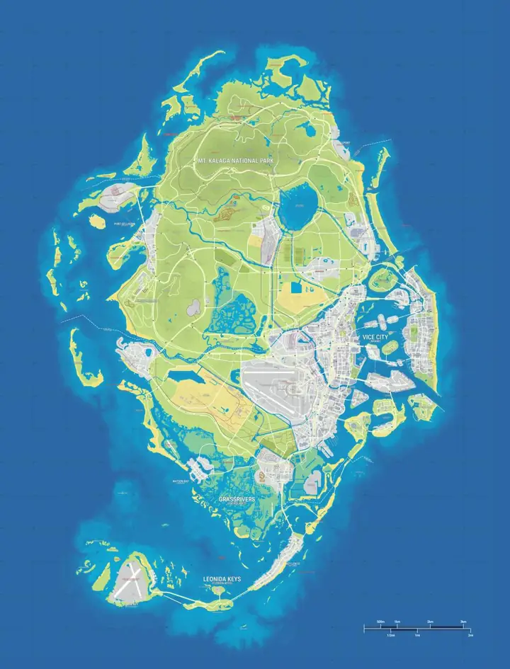
Use the GTA 6 map with real locations to see where Florida helps explain Leonida. Switch from Game map to Real locations to isolate community-mapped points that have a proposed counterpart. The background stays in Leonida, so you can see where each reference fits into the game. The address in a point’s details is for comparison with the physical location.
GTA 6 locations and their real-world counterparts
The table starts with broad geographic comparisons and then lists individual records from gtadb.org. A region can borrow from several locations. Published Rockstar profiles establish what the fictional areas are like. The proposed real-world matches are community inferences and are not officially confirmed.
| GTA 6 location | Real-world location | Evidence |
|---|---|---|
| Leonida | Florida | The peninsula, offshore island chain and subtropical wetlands give the state its broad Florida outline. |
| Vice City | Miami and Miami Beach, Florida | The beachfront hotel strip, mainland skyline and Little Cuba point to Miami and its coastal neighbor. |
| Leonida Keys | Florida Keys | A low island chain linked by roads and bridges, with Key Largo matches around Key Lento. |
| Grassrivers | Florida Everglades | Rockstar’s airboat wetlands match the Everglades landscape. The visitor center offers a more specific visual reference. |
| Port Gellhorn | Panama City area, Florida | Several community matches line up along US 98. This is a strong reference for parts of the town. |
| Ambrosia | Clewiston area, Florida | The Allied Crystal refinery and surrounding farmland echo Clewiston’s sugar industry south of Lake Okeechobee. |
| Mount Kalaga National Park | Southern Appalachians | Forested ridges and the profile of the peak suggest Appalachian terrain. The summit has a separate community match. |
| Kelly County | Composite, including parts of northeast Florida | Individual matches near Macclenny and Hilliard suggest source material. They cannot establish a county-wide equivalent. |
| Boardwalk | Hotel Breakwater, Miami Beach | Art Deco frontage on Ocean Drive. |
| Vice Museum of Art | The Bass, Miami Beach | Museum in the community’s Vice Beach match. |
| The Rusty Anchor | Caribbean Club, Key Largo | Waterside bar off the Overseas Highway. |
| Bridge | Lake Surprise Viaduct, North Key Largo | Bridge approach at the north end of the Keys. |
| Grassrivers Visitor Center | Guy Bradley Visitor Center, Flamingo | Everglades visitor center recorded by GTADB. |
| Pawn & Gun | East US 98, Panama City | Storefront along the highway’s retail strip. |
| Bingo Hall | Mr. Bingo, Panama City | Bingo hall on the US 98 Business corridor. |
| Airfield | Airglades Airport, Clewiston | Airfield in the sugar-growing district. |
| Sugar Mill | U.S. Sugar Mill, Clewiston | Industrial mill beside the rail corridor. |
| Taco Bomb | South 6th Street, Macclenny | One recorded storefront match in Kelly County. |
| Starlet Motel Sign | Dixie Motel, Hilliard | The motel sign’s recorded reference. |
| Starlet Motel | Economy Inn, Lawtey | The motel building’s separate reference. |
| Mount Kalaga | Table Rock Mountain, North Carolina | Community match for the shape of the peak. |
How we matched them
At the regional level, compare geography first. The shape of the peninsula, the water gaps between islands, and the distribution of marshes can help narrow down a reference. A coastline can be compressed or rotated in the game, so a broad shape gives a starting point for comparison.
For landmarks, compare the building’s silhouette, the position of entrances, and the shapes of neighboring structures. A hotel frontage by itself is a weak signal. A cluster of nearby façades or a bridge lined up with the same kind of approach road gives a better basis for comparison. The addresses in the table come from the site’s community data. Where matches involve roads, compare junctions and the direction of the route before drawing conclusions about the whole district.
The full site inventory contains 837 points in 38 categories (map data as of November 10, 2026).Rockstar has profiled 6 major settings. LeonidaBayestimates 82.6 km² of land on the YANIS V17 reconstruction. Rockstar has not confirmed the area, so it cannot be used to turn gameplay distances into Florida driving directions.
Real-world influences across Leonida’s six featured regions
Vice City
Compare the dense mainland neighborhoods with the hotel strip in Vice Beach. Wynwood gallery references are useful inland, while the Ocean Drive examples make more sense together along the beach. Search for a specific establishment if you want the building model and its recorded address.
Leonida Keys
The progression from one island to the next resembles traveling the Overseas Highway. A bridge and a waterside business may provide better clues than the outline of an individual island. Key Lento is a useful map anchor for the recorded Key Largo and nearby Keys references.
Grassrivers
The Everglades comparison helps explain the flat water, patches of vegetation and the airboats in Rockstar’s material. The Grassrivers Visitor Center gives you a point at which to start examining the wetland. A visitor center match applies to that site, and the landscape comparison is broader.
Port Gellhorn
Motels and businesses along the US 98 corridor help explain some of Port Gellhorn’s roadside scenes. The Panama City area has several references within driving distance of one another. That pattern supports a corridor comparison, and the game can still rearrange the buildings.
Ambrosia
Rockstar puts the Allied Crystal sugar refinery at the center of its profile. The concentration of references around Clewiston makes the southern shore of Lake Okeechobee useful context for the refinery and fields. Look up the separate airfield and mill points to distinguish the matches.
Mount Kalaga National Park
The wooded ridges and prominent peak are closer in character to parts of the southern Appalachians than to the Florida peninsula. The Table Rock entry refers to the shape of Mount Kalaga. It provides little evidence for the location of roads or the perimeter of the fictional park.
Use the comparisons at the scale of the evidence. A named match is most useful for recognizing one building. A series of matches along a highway can explain a district’s appearance. An entire region may still combine landmarks from cities hundreds of miles apart.
Browse the matching map categories
Use a category page to check surrounding game landmarks, including those with no recorded comparison. A nearby marker can be useful for orientation without having a proposed model.
- Safehouses
- Ammu-Nation & Gun Stores
- Airports & Airfields
- Bars & Pubs
- Restaurants & Fast Food
- Attractions & Museums
- Hotels & Motels
- Landmarks & Nature
- Offices & Businesses
- Industrial Sites & Utilities
- Regions & Cities
Frequently asked questions
Is Vice City the same as Miami?
Vice City draws on Miami and Miami Beach. The comparison helps explain its coastal layout and architecture. Street names, routing and neighboring districts follow the game’s geography.
Does Rockstar confirm the real-world matches?
Rockstar publishes profiles of the fictional settings. The specific comparisons on this page are community inferences, not officially confirmed real-world equivalents.
What changes when I select Real locations?
The YANIS V17 map stays in place and only markers with a recorded real-world reference or a regional comparison remain. Open a marker to see its counterpart. Marker positions are game coordinates.
Which Florida town inspired Ambrosia?
Clewiston is a plausible inspiration for Ambrosia’s sugar industry. The mill, airfield and fields listed here are records from the community dataset, so each match should be read as evidence for that feature.